Uskudar / Altunizade / Istanbul
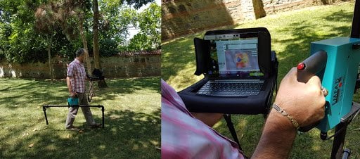
EMFAD ® - ScanDS program is a data processing software that makes measurements by using the conductivity of foreign objects under the soil, processes and displays these measurements. This software provides 2D and 3D - imaging, interpretation, modeling, documenting and printing possibilities of the measurements. You can examine the new model in detail and get it by testing it in the field. EMFAD DS The program is very easy to use and the flow of the menus is self-explanatory. In addition, interpretation of your shots in the field, information support and all kinds of information flow on technical issues are provided.
EMFAD – measurement method based on the measurement of ground conductivity anomalies caused by
– Metals, metal objects, barrels, pipes, cables, channels, concrete shelters, cellars, electrolytes, etc.
– It can detect conductivity/transport anomalies caused by cavities, ground movements, fillings, intercalations, soil or rock cracks, wells/culverts.
Generally, its application areas worldwide are archaeology, geophysics, geology and hydrology. It is used in different fields, such as detection and drilling of contaminated areas, ground surveys of construction sites, mineral exploration and detection, road construction and durability determinations, waste research and enrichment studies, treasure searches, etc., and it provides users with precise and clear results and ensures their success.